| Date of Discovery: 1990 | Age of the Site: 1990 | Excavation Team: 1990 | Extent of Excavation: 1990 |
| Open to Public: 1990 | GPS Coordinates: 1990 | Elevation above Sea Level: 1990 | Websites: 1990 |

ARCHITECTURAL MARVELS OF THE NEOLITHIC AGE
The architectural achievements of Nevali Cori stand as a testament to the advanced capabilities of early Neolithic societies. The site’s meticulously constructed rectangular buildings, crafted from precisely cut limestone, defy previous assumptions about the era’s architectural limitations. These structures, characterized by their durability and sophistication, served multifaceted roles as both dwellings and ceremonial spaces, illustrating an early integration of daily and spiritual life. The architectural designs seen at Nevali Cori, including stone pillars and terrazzo floors, highlight a sophisticated understanding of spatial organization and community planning far ahead of its time. This architectural ingenuity not only provided a foundation for future advancements in building techniques but also fostered a sense of community and cohesion among its inhabitants.

A PROTO-GÖBEKLI TEPE
The discovery of Nevali Cori has reshaped our understanding of Neolithic progression in the region, suggesting a possible ideological and cultural continuity leading to the construction of Göbekli Tepe. The parallels in architectural styles and religious symbols between the two sites indicate that Nevali Cori might have served as an inspiration or even a precursor to the later monumental achievements at Göbekli Tepe. This connection underscores the site’s significance in tracing the evolution of religious and societal structures within early human communities, providing a clearer picture of the gradual development of complex belief systems and communal identities.THE DAWN OF ARTISTIC EXPRESSIONArtistic artifacts unearthed at Nevali Cori represent some of the earliest known depictions of the human form, marking a milestone in the history of artistic expression. These statues and reliefs, with their intricate detailing and symbolic significance, offer invaluable insights into the community’s spiritual beliefs, social structures, and aesthetic values. The presence of such sophisticated artistry challenges previously held notions about the artistic capabilities of Neolithic peoples, suggesting a complex understanding of human and divine representation. Through these artistic expressions, we gain a deeper appreciation for the cultural richness and intellectual depth of Nevali Cori’s inhabitants.

FROM NOMADS TO FARMERS
The evidence of agriculture at Nevali Cori signifies a monumental shift in human history from nomadic lifestyles to settled farming communities. The cultivation of wheat and barley at this site marks one of the earliest instances of agricultural practices, laying the groundwork for the development of stable communities and the eventual rise of civilizations. This transition not only altered the socio-economic fabric of Neolithic societies but also set in motion the complex dynamics of agricultural development, population growth, and urbanization that would define human progress for millennia.RITUALS AND ANCESTORSThe ritualistic practices and ancestor veneration of Nevali Cori reveal the complex belief systems of early Neolithic communities, offering an intriguing window into their spiritual life. The site’s archaeological findings, including skull fragments and other human remains, suggest rituals that underscored the community’s reverence for their ancestors and the spiritual world. These practices reflect an intricate web of beliefs regarding life, death, and the cosmos, offering profound insights into the early development of religious thought and the role of ritual in fostering communal bonds and continuity.
NEVALI CORI’S ENDURING LEGACY
As we delve deeper into the mysteries of Nevali Cori, its enduring legacy becomes increasingly apparent. This ancient site not only illuminates the ingenuity and resilience of early Neolithic societies but also serves as a beacon of innovation that influenced subsequent developments in architecture, art, agriculture, and spirituality. By exploring Nevali Cori’s remarkable contributions to human history, we gain a deeper understanding of our ancestors’ journey from the shadows of prehistory into the light of civilization, forever altering our perceptions of the Neolithic age and its lasting impact on the course of human development.
| Date of Discovery: 1990 | Age of the Site: 1990 | Excavation Team: 1990 | Extent of Excavation: 1990 |
| Open to Public: 1990 | GPS Coordinates: 1990 | Elevation above Sea Level: 1990 | Websites: 1990 |

Taşlı Tepe or Taşlıtepe approximately 1 km north of Başbük village in Siverek district.. It was a settlement used as a cult centre during the Pre-Pottery Neolithic period. The archicectural elements has been destroyed by agricultural activity.
The small finds at Tashli Tepe are mostly flint and a small number of obsidian tools mainly blades.
Sources:
- Bahattin Celik, A small-scale cult centre in Southeast Turkey>Harbetsuvan Tepesi, Documenta Praehistorica XLIII (2016)
- Gül Güler, Bahattin Çelik and Mustafa Güler: New Pre-Pottery Neolithic sites. and cult centres in the Urfa Region, Documenta Praehistorica XL (2013)

| Date of Discovery: 1990 | Age of the Site: 1990 | Excavation Team: 1990 | Extent of Excavation: 1990 |
| Open to Public: 1990 | GPS Coordinates: 1990 | Elevation above Sea Level: 1990 | Websites: 1990 |

Located in modern Turkey, Göbekli Tepe is one of the most important archaeological sites in the world. The discovery of this stunning 10,000 year old site in the 1990s CE sent shock waves through the archaeological world and beyond, with some researchers even claiming it was the site of the biblical Garden of Eden. The many examples of sculptures and megalithic architecture which make up what is perhaps the world’s earliest temple at Göbekli Tepe predate pottery, metallurgy, the invention of writing, the wheel and the beginning of agriculture. The fact that hunter–gatherer peoples could organize the construction of such a complex site as far back as the 10th or 11th millennium BC not only revolutionizes our understanding of hunter-gatherer culture but poses a serious challenge to the conventional view of the rise of civilization.
Göbekli Tepe (Turkish for the ‘hill of the navel’) is a 1000 foot diameter mound located at the highest point of a mountain ridge, around 9 miles northeast of the town of Şanlıurfa (Urfa) in southeastern Turkey. Since 1994 CE, excavations conducted by Klaus Schmidt of the Istanbul branch of the German Archaeological Institute, with the cooperation of the Şanlıurfa Museum, have been taking place at the site. Results to date have been astounding; especially bearing in mind the excavators estimate that their work has uncovered a mere 5% of the site.
Göbekli Tepe consists of four arrangements of monolithic pillars linked together by segments of coarsely built dry stone walls to form a series of circular or oval structures. There are two large pillars in the center of each complex which are encircled by slightly smaller stones facing inward. Archaeologists believe that these pillars could have once supported roofs. The structures vary in size between around 33 and 98 feet in diameter and have floors made of terrazzo (burnt lime).
The Megaliths at Göbekli Tepe

The megaliths themselves, 43 of which have been unearthed so far, are mainly T-shaped pillars of soft limestone up to around 16 feet in height, and were excavated and transported from a stone quarry on the lower southwestern slope of the hill. Geophysical surveys on the hill indicate that there are as many as 250 more megaliths lying buried around the site, suggesting that another 16 complexes once existed at Göbekli Tepe.
Although some of the standing stones at Göbekli Tepe are blank, others display extraordinary artwork in the form of elaborately carved foxes, lions, bulls, scorpions, snakes, wild boars, vultures, water fowl, insects, and arachnids. There are also abstract shapes and one relief of a naked woman, posed frontally in a sitting position. A number of the T-shaped stones have depictions of what appear to be arms at their sides, which could indicate that the stones represent stylized humans or perhaps gods. Although the pictograms at Göbekli Tepe do not represent a form of writing, they may have functioned as sacred symbols whose meanings were implicitly understood by local populations at the time.
The depictions of vultures at Göbekli Tepe have parallels at other Anatolian and Near Eastern sites. The walls of many of the shrines at the large Neolithic settlement of Çatal Höyük (in existence from approximately 7500 BCE to 5700 BCE) in south-central Turkey were adorned with large skeletal representations of vultures.
One theory put forward to explain the prominence of vultures in the early Anatolian Neolithic is in the context of possible excarnation practices suggesting a funerary cult. After death, bodies would have been deliberately left outside and exposed, perhaps on some kind of wooden frame, where their skeletons were stripped of flesh by vultures and other birds of prey. The skeletons would then be interred somewhere else. Perhaps the ritual of excarnation was the focus of a cult of the dead practiced by the inhabitants of Göbekli Tepe, as it certainly seems to have been elsewhere in Anatolia and the Near East in the Pre-Pottery Neolithic.
Curiously, Schmidt and his team have so far found no evidence of settlement at Göbekli Tepe – houses, cooking hearths, and refuse pits are all absent. The archaeologists did, however, find over 100,000 animal bone fragments, many of which exhibited cut marks and splintered edges which indicate that animals were being butchered and cooked somewhere in the area. The bones came from wild game such as gazelle (which accounted for over 60% of the bones), boar, sheep and red deer, and different species of birds such as vultures, cranes, ducks and geese. All of the bones were from wild species; evidence that that the people who inhabited Göbekli Tepe were hunter-gatherers rather than early farmers who kept domesticated animals.
Similar Sites in the Area
Due to the presence of multiple monumental complexes at such an early date Göbekli Tepe is a somewhat unique site. However, there are some parallels with the site at the early Neolithic settlement of Nevalı Çori, on the middle Euphrates River in Eastern Turkey, which lies only 12.5 north-west of Göbekli Tepe. The main temple at Nevalı Çori was dated to around 8,000 BCE, perhaps a thousand years later than Göbekli Tepe. The cult complexes at the settlement had a number of features in common with Göbekli Tepe, such as a terrazzo-style lime cement floor, monolithic T-shaped pillars built into dry stone walls, and two free-standing pillars in the center of the complex area. The T-shaped pillars show reliefs of what appear to be human hands. Unfortunately, Nevali Çori is now lost, submerged beneath a lake created by the Atatürk Dam in 1992 CE.


| Date of Discovery: 1990 | Age of the Site: 1990 | Excavation Team: 1990 | Extent of Excavation: 1990 |
| Open to Public: 1990 | GPS Coordinates: 1990 | Elevation above Sea Level: 1990 | Websites: 1990 |

Şanlıurfa-Yeni Mahalle is a settlement located at Şanlıurfa downtown area within the ancient ramparts of Şanlıurfa. The settlement is underneath Yeni Mahalle district, which accommodates Balıklıgöl sacred area. In 1997 an excavation was carried out at the ground section of 15 m on Yeniyol Avenue in Yeni Mahalle district57.
The excavation carried out revealed two terrazzo floors of circular buildings. The circular wall of one of the floors were unearthed and revealed as intact, although partially. The small findings discovered from the section are Byblos and Aswad type arrowheads made of flintstone, sickle blades, shoulder blades, cores and very scarce ob– sidian flakes, and arrowhead fragments. The C14 analyses performed on the carbonated plant remains revealed that the settlement is dated back to cal. 8600 BC.
| Date of Discovery: 1990 | Age of the Site: 1990 | Excavation Team: 1990 | Extent of Excavation: 1990 |
| Open to Public: 1990 | GPS Coordinates: 1990 | Elevation above Sea Level: 1990 | Websites: 1990 |

The idea of opening a museum in Şanlıurfa occurred in 1948, and the first attempt to build this museum started with collecting the existing artefacts in a storage room in Ataturk Primary School. In 1956, a place was reserved in the Sehit Nusret Primary School, and artefacts started to be collected there. After this, the area was not enough for the artefacts to be kept, and the urgency of exhibiting these artefacts, which show the history of thousands of years of the region, led to the need for a new museum building to be built. In 1965, in the Sehitlik Area of the Şanlıurfa city centre, the construction of the museum building started on a 1500 square meters area.
Şanlıurfa Museum was opened to visitors in 1969 after the building construction, and the exhibition arrangement works were completed. However, the intensity of archaeological research in Şanlıurfa caused this museum to be insufficient after a while. For this purpose, the new three-storey “Şanlıurfa Archeological Museum” in southern Sanliurfa, which is a place of renewal and is close to the Balikligol, shopping malls and hotels in the city and is on a 60.000 decare area and has a 29.000 square meters indoor space; “Mosaic Museum” on an area of 5,000 square meters, where the mosaics unearthed in Haleplibahçe will be exhibited; and between these two museums, the archaeopark area where experimental archaeological studies can be carried out between both museums, was built and opened to visitors in 2015. Şanlıurfa Archeology Museum is designed as a large complex. It contains 14 main exhibition halls, and 33 animation areas are available.
In the Archaeopark area, located between the Archeology Museum and the Mosaic Museum, there are examples of buildings that reflect the architectural characteristics of the period, listed chronologically, and places where productions for tourism can be made, primarily reflecting the art of the period. In addition, there is an excavation training area where experimental archaeological studies can be conducted to better explain how excavation works are carried out in the Archeopark area, especially for school-age children.
Among the 65.000 pieces in the Şanlıurfa Archaeological Museum’s warehouses, 5,000 artefacts are currently on display. The ones that are not shown are planned to be revealed by turns. In the museum’s exhibition halls, chronologically, first, the Paleolithic Age finds and periodical reenactments. Then, the world’s oldest human-size statue, “Yenimahalle Statue” dated to the Neolithic Period and in chronological order, Göbeklitepe excavation finds and reenactments, Nevali Çori public building, Chalcolithic Period, Bronze and Iron Age finds and reenactments, artefacts from the Hellenistic, Roman, Eastern Roman and most recent Islamic Periods are exhibited. Şanlıurfa Archeology Museum, which has a privileged place among the world museums in terms of Göbeklitepe and Neolithic period artefacts, and the Mosaic Museum with its “Amazon Women” depicted on the mosaic for the first time in the world, await visitors from our country and the world.
Source : Şanlıurfa Museum Directorate
Address : Haleplibahçe Mahallesi, 2372. Sk. No:74/1, 63200
E-mail : sanliurfamuzesi@kultur.gov.tr
Phone : +90-414 313 15 88
| Date of Discovery: 1990 | Age of the Site: 1990 | Excavation Team: 1990 | Extent of Excavation: 1990 |
| Open to Public: 1990 | GPS Coordinates: 1990 | Elevation above Sea Level: 1990 | Websites: 1990 |

Introduction
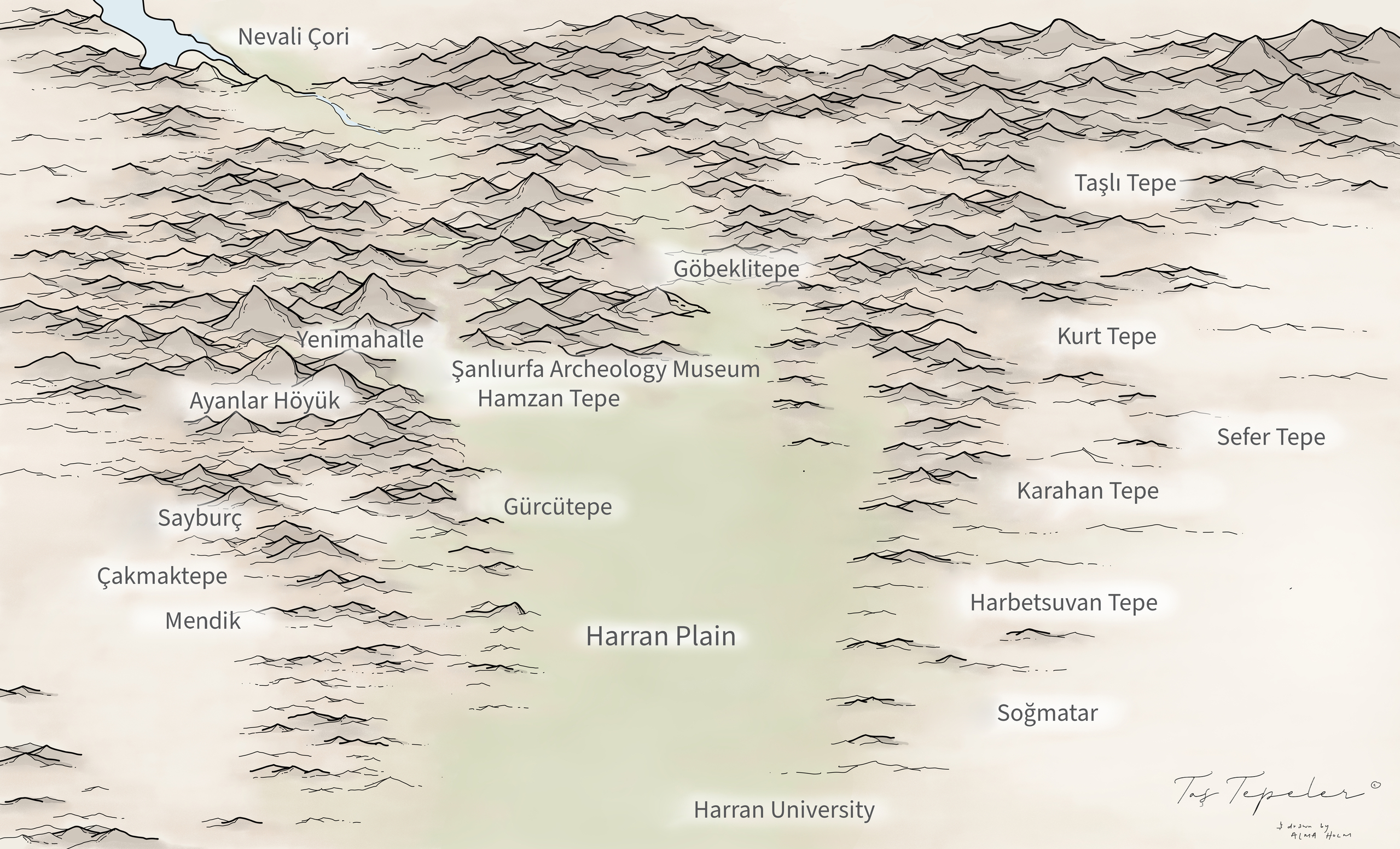
The site at Hamzan Tepe – which was first discovered in 2000 during the Sanlıurfa Culture Inventory – lies within the city boundaries of Sanlıurfa (formerly Urfa and in ancient times, Edessa) in south- eastern Turkey as the cornerstone of the Fertile Crescent. Hamzan Tepe is now located 10km south of modern Sanlıurfa city center. Like Göbekli Tepe, Karahan Tepe and Sanlıurfa-Yeni Mahalle PPN sites, Hamzan Tepe also lies in the high plateaus on the edge of Harran Plain (Map 1).
During surveys of Hamzan Tepe in 2000, pools cut into the bed rock and plenty of flint stone tools were determined. By means of these findings it is under- stood that this site was used as a settlement both in the Lower Palaeolithic and Pre-Pottery Neolithic Periods. Also, a T-shaped pillar which is also familiar through Nevali Çori and Göbekli Tepe was found. As a result of a new survey in 2010, new round plan architectural remains excavated by treasure hunters found out.
Location
The settlement at Hamzan Tepe is located approximately 600 meters above sea level at 0 482 41 50 North-South (X), 0 410 42 41 East-West (Y).
The settlement was constructed on bed-rock, in a mountainous region called the Fatik Mountains (Fig. 1). In this region, without water sources, there is a high number of calcerous rocks formed as a consequence of erosion. The preserved part of the settle- ment covers an area of approximately 5000m2. On the northern edge is the large city dump of Sanlıurfa. Harran Plain, the most important plain of the region lies about 1km east of the settlement. There are plenty of flint-stone faces on the southeastern edges of Hamzan Tepe. About 400m west of the settlement, there are basalt blocks.
Considering the flint finds from the survey, it is estimated that Hamzan Tepe was used as a temporary open air site in the Lower Palaeolithic and as a minor settlement in the Pre-Pottery Neolithic (Çelik 2004).
| Date of Discovery: 1990 | Age of the Site: 1990 | Excavation Team: 1990 | Extent of Excavation: 1990 |
| Open to Public: 1990 | GPS Coordinates: 1990 | Elevation above Sea Level: 1990 | Websites: 1990 |

Ayanlar Höyük was discovered in 2013. It is located near the village of Ayanlar, about 30 km west of Şanlıurfa.
Although no “T” shaped stelae could be found in Ayanlar Höyük, this find gives important clues that it could be a cult center like Göbekli Tepe and Karahan Tepe.
The obelisk tradition, seen from the end of Phase A to the middle of Phase B of the Pre-Pottery Neolithic period, seems to have disappeared at the end of Phase B of the Pre-Pottery Neolithic period. Archaeologists anticipate that, thanks to future research, there is also the stelae tradition related to the Pre-Pottery Neolithic period in Gaziantep, Mardin, and Adıyaman provinces and that many settlements will be revealed.
Researchers think that since the end of the 9th millennium BC, such settlements were abandoned by covering them with soil, and the first agricultural communities began to be established on the plains and near the waters.
The recent finds from the Karahantepe excavations are exhibited at the Şanlıurfa Archaeological Museum in the “Karahantepe and Neolithic Human Exhibition”, which opened on September 23, 2021.
In this article, excerpts are made from the article titled “The Neolithic Period in and around Urfa in the Light of New Findings” by Bahattin Çelik and Kaya Tolon.
| Date of Discovery: 1990 | Age of the Site: 1990 | Excavation Team: 1990 | Extent of Excavation: 1990 |
| Open to Public: 1990 | GPS Coordinates: 1990 | Elevation above Sea Level: 1990 | Websites: 1990 |

Introduction
The first settlement in Sayburç, which is 19 km away from the city center of Şanlıurfa, took place in the Pre-Pottery Neolithic Period, the area was settled again later in the Roman Period, and the village known as Sayburç was established in the 1950s. This cultural continuity observed in the settlement emphasizes that this is a living mound.
There are two Neolithic settlements, one to the north and the other south of the modern village. In the north, on the southwest slopes of a small mound dating to the Roman period, structures built directly on the bedrock were found. One of the partially excavated structures has a circular plan, probably 15 m in diameter, with a base carved into the bedrock. This is a gathering place used for public purposes. The dimensions of the building, its base carved into the bedrock, its bench parallel to the wall and the obelisk nests on the bench are characteristic for the period and region. Undoubtedly, the most important feature of the building is the reliefs carved on the bench stretching along the wall. These reliefs consist of two men, two leopards and a bull figure. For the first time, these figures were depicted together to form a story in Sayburç.
A residential area was identified in the south of the private buildings in the north. Contiguous structures built by adding to each other reflect the first applications of corner connection and rectangular plan and show that T-shaped obelisks are not only in public buildings but also in residences. Although the custom and monumental building tradition in the region is well known, evidence of daily life, which is not very detailed, is extensively researched in Sayburç.


| Date of Discovery: 1990 | Age of the Site: 1990 | Excavation Team: 1990 | Extent of Excavation: 1990 |
| Open to Public: 1990 | GPS Coordinates: 1990 | Elevation above Sea Level: 1990 | Websites: 1990 |


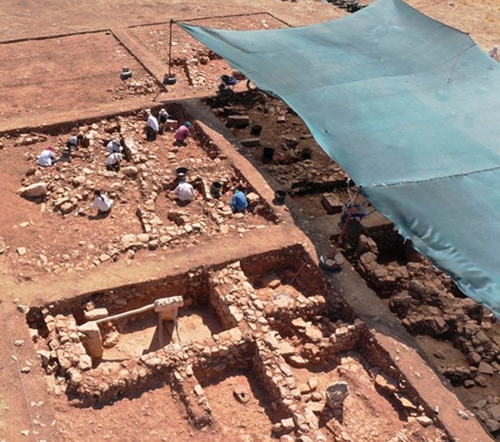
Gürcütepe is located in the northwest of the Harran Plain, 4 km southeast of Şanlıurfa city center. The settlement was established on a fertile land to the south of Sırrın Stream and right next to the natural spring waters.
Surveys carried out in the region in the 90s revealed that Gürcütepe consists of eight settlements, four of which are mounds and the other four are flat, and that the earliest occupation is dated to the end of the Pre-Pottery Neolithic Age.
As a matter of fact, sounding excavations in the mounds revealed a similar architectural stratification known from the Çayönü Tepesi settlement in Diyarbakır. The “Large Roomed Buildings” and “Cell Planed Buildings”, in which two possible special structures were partially identified, are the architectural phases identified.
The second period excavations in Gürcütepe started in 2021. In the 20 years that passed between the two excavation campaigns, the tops of the settlements were subject to resettlement. For this reason, excavation works have started to be carried out in an area used as agricultural land. The agricultural activities carried out in the area and the re-usage of old structures in the houses of the modern village have greatly damaged the settlement.
Interdisciplinary studies show that people living in Gürcütepe, unlike other settlements, started to produce food, domesticated goats, sheep, pigs and possibly cattle, and made agricultural experiments. Therefore, it is seen that a transition to a new social and economic model has been made with the Gürcütepe settlement in the Harran Plain.
| Date of Discovery: 1990 | Age of the Site: 1990 | Excavation Team: 1990 | Extent of Excavation: 1990 |
| Open to Public: 1990 | GPS Coordinates: 1990 | Elevation above Sea Level: 1990 | Websites: 1990 |

Çakmaktepe unveils a significant chapter in Anatolian history, predating Göbeklitepe and revealing the earliest traces of settled life in the region. The presence of intricately carved structures into the bedrock, exceeding 15 meters in diameter, signifies that even during the initial phases of transitioning to settlement, hunter-gatherer societies not only sought sustenance but also placed considerable importance on social ties and communal life.
Located on the Fatik Mountains near the village of Ödüllü in the Eyyübiye district, approximately 20 km southwest of Şanlıurfa, Çakmaktepe has been the focus of excavations. These efforts have unearthed circular pit-based domestic shelters and specialized structures carved into the bedrock. The prevalence of pit-based shelters suggests both a dense population and highly favorable environmental conditions for habitation. The bedrock served as the flooring for these structures, with terrazzo floor experiments conducted on sloped bedrock areas.

Intriguingly, certain buildings contained deliberately positioned wild animal heads at the base of walls, suggesting ritualistic practices. All of these animal heads underwent burning outside the structures before being placed within these spaces.
The presence of sizable structures, exceeding 15 meters in diameter, underscores that hunter-gatherer communities, including those at Göbeklitepe and Karahantepe, prioritized not only sustenance but also social connections. This discovery implies that these unique structures have a much older origin than previously recognized, emphasizing the early existence of communal rituals during the initial stages of settling down. Contrary to earlier assumptions, the findings at Çakmaktepe indicate that settlement layouts, incorporating private structures alongside domestic ones (as seen in Nevali Çori and Çayönü), have roots dating further back than previously believed.
Based on flint chipped stone data, Çakmaktepe is dated to the end of the Epipaleolithic and the onset of the Pottery-Free Neolithic (PPNA). As the oldest identified settlement of settled hunter-gatherers in Anatolia, Çakmaktepe challenges previous notions, revealing that the transition to settled life in the region is far more ancient than previously understood.

Harran, situated 44 km southeast of Şanlıurfa near the Syrian border, was an important Mesopotamian trade center as early as 2300 BCE on a road running south to Nineveh in modern Iraq.
| Date of Discovery: 1990 | Age of the Site: 1990 | Excavation Team: 1990 | Extent of Excavation: 1990 |
| Open to Public: 1990 | GPS Coordinates: 1990 | Elevation above Sea Level: 1990 | Websites: 1990 |
Historical overview:
During the first half of the 6th century, BCE Babylonian King Nebuchadnezzar ruled Harran. The town was home to the Sabian worshippers of the moon god Sin. The mystical Sabian sect was, because of its belief in one God, recognised by Islam as on a par with Christianity and Judaism. The Sabian religion united Neo-Platonic philosophy with Babylonian astrology, considering the planets as embodying spiritual beings created by God as part of the universe, especially the moon, whose god they called Sin. The Sabians had a holy script, ceremony and a kind of communion. Facing always to the north, they prayed at dawn, midday and sunset. The principal deity was worshipped in the form of a pillar or holy stone, and under him were the sun god (Shamash), the moon god (Sin), Saturn (Kronos), Jupiter (Bel), Mars (Ares), Venus (Balti), and Mercury (Nabuq). Every day of the week was dedicated to one of these deities.
The main moon god sanctuary was at Harran where the cult was practised into the 12th century. In 830 CE, the caliph Al-Mamun was filled with indignation at the dress, long hair and scandalous behaviour of the Sabians and gave them the choice of converting to Islam or Christianity or face exile or hanging. One medieval Arab chronicler wrote of their wild practices: “There was no hill that was not moist with the blood of sacrifices and no high place that was empty of libations. Youths in multitudes were given as sacrifices, and maidens slaughtered to female idols and to the sun and the moon and Venus and other luminaries”.
The original moon temple at Harran was one of the holiest sanctuaries of the Middle East, and the Harran astronomers were held in high regard by the brilliant court of the Abbasids in Baghdad in the 9th century. Their religious emblem of a crescent and an eight-pointed star was subsequently adopted by a variety of esoteric sects and the spread of the crescent and star symbol, still so prevalent in the Islamic world, seems to date from that time.
According to the Old Testament, Harran was also the place where Terah and his son Abraham, his grandson Lot and Abraham’s wife Sarah went after leaving Ur. It was 18 centuries before Christ that Abraham was called from Ur of the Chaldees to go to Canaan according to the Old Testament. He stopped at Harran for several years until God told him to move on:
“So Abram departed, as the Lord had spoken unto him: and Abram was seventy and five years old when he departed out of Harran. And Abram took Sarai his wife and Lot his brother’s son and all their substance that they had gathered, and the souls that they had gotten in Harran; and they went forth to go into the land of Canaan (Genesis 12:4-5).”
Although Abraham went on to Canaan after his father Terah died, some relatives apparently remained. Much later Abraham sent a servant back to Harran to find a wife from among his relatives for his son Isaac. The traditional site of Jacob’s Well, where Rebecca drew water for Abraham’s servant is about one km west of the Harran city walls. According to tradition, Harran was where Jacob laboured for twenty years for his father-in-law Laban. Travellers keen on walking and at the same time supporting the local economy can follow the so-called “Abraham’s Path” that begins in Turkey, runs for 170 km through flattish semi-arid landscapes and incorporates the major sights of Urfa, Göbekli Tepe, the Well of Job, Harran, the Well of Jacob and Sogmatar.
Harran was also part of the Achaemenid Empire, which was replaced two centuries later by that of the Macedonian king Alexander the Great. The conqueror may have visited Harran in the late summer of 331 BCE. After Alexander’s death in 323 BCE, Harran was part of the empire of the Seleucids, the Macedonian dynasty ruling in Asia. They settled Macedonian veterans at Harran, which remained a recognisable entity after the Seleucid empire had been replaced by that of the Parthians.
In 53 BCE, the Roman general Crassus invaded Parthia. The descendants of the Macedonians sided with him, but he was defeated by a Parthian commander, called Surena in the Greek and Latin sources, who must have been a member of the Parthian Sûrên clan. The battle of Harran – or Carrhae as the Romans called it – was the beginning of a series of border wars that were to last for centuries.
| Date of Discovery: 1990 | Age of the Site: 1990 | Excavation Team: 1990 | Extent of Excavation: 1990 |
| Open to Public: 1990 | GPS Coordinates: 1990 | Elevation above Sea Level: 1990 | Websites: 1990 |

“T” shaped pillars were unearthed at Kurt Tepesi that was recently discovered in 2013 at Şanlıurfa region as a result of the survey studies. The findings unearthed from other recently discovered sites were circular building remains that are rather characterized as domestic architectural buildings resemblinge the features of the period: stone vessels, grinding stones, pestles, and lithic tools. One of the intriguing sites identified in the same year is the Ayan- lar Höyük settlement. Several findings unearthed from this settlement that cover a land of 140 decares indicate that this settlement might be one of the settlements that accommodate a “T” shaped pillar. Harbetsuvan Tepesi, on the other hand, was discovered during the surveys conducted in 2014. “T” shaped pillars were discovered in this settlement as well. The settlements recently discovered in years 2013 and 2014 are located at the mountain ranges and plateaus located east and west of the Harran plain.
SETTLEMENTS THAT ACCOMMODATE “T” SHAPED PILLAR Kurt Tepesi
Discovered for the first time during the surveys conducted in 2013, Kurt Tepesi settlement is located 47 km east of Şanlıurfa province and 3 km south of Sumaklı village. (Fig. 1). Its altitude from sea level is 730 m. The settle- ment is also known as Kuça Gura by the local community.
Kurt Tepesi settlement is located on a hill that dominates the Çoban Creek Pass, which serves as a passageway between Harran Plain and Viranşehir region (Fig. 2). It is a small mound established on a ridge formed by high calcareous plateaus, which is very poor in terms of soil. The western section of the mound that covers approximately 7-decare area is distorted due to illegal excavations. Moreover, a high voltage transmission line pole is located at the north end of the mound. Small cavern groups and a pool carved to the bedrock are determined at the calcareous rocks surrounding the mound. Furthermore, the quarries contemplated to be the site for extracting the “T” shaped pillars are also located northeast of the hill. A site where a “T” shaped pillar excavated and removed is identified in an illegal excavation pit at Kurt Tepesi from Pre-Pottery Neolithic period with no ceramics (Fig. 3). During the surveys conducted at the villages in the vicinity, two pillars removed from their original site were discovered in Kösecik village located circa 6 km south- east of the hill (Fig. 4)18.
| Date of Discovery: 1990 | Age of the Site: 1990 | Excavation Team: 1990 | Extent of Excavation: 1990 |
| Open to Public: 1990 | GPS Coordinates: 1990 | Elevation above Sea Level: 1990 | Websites: 1990 |
Sefer Tepe is a small, broad and shallow mound located c. 72km east of Sanlıurfa, within the modern province borders of Viransehir. The mound is located at 600m altitude above sea level and covers a surface area of c. 7000m2. A country house is located in the south-eastern corner of the site. The closest water source is Yukarı Cırcıp creek, 1.5km to the east. The geological foundation is of calcareous rock and the closest basalt source is located 1km to the east. The most intriguing aspect of the Sefer Tepe site are the 16 in-situ T-shaped pillars. Most of the pillars were buried and placed side-by-side in a conjugate formation at c. 1.5 up to 2m intervals. The upper sections above the surface are c. 50cm long and 20cm wide. The positioning of the pillars is very similar to the architecture at Göbekli Tepe Level II and the monolithic in-situ pillars on the surface at Karahan Tepe. Moreover, another pillar was revealed during the construction of the country house in the south-eastern corner of the site. This pillar was found intact; its length is 198cm and the width of the head section is 72cm, the width of the body section 54cm and the thickness 25cm. The head section of this undecorated stele is extremely flattened; it has features identical with the pillars discovered at Nevali Çori, Göbekli Tepe, Karahan Tepe, Hamzan Tepe and Taşlı Tepe.

Author/Source: Bahattin Çelik
| Date of Discovery: 1990 | Age of the Site: 1990 | Excavation Team: 1990 | Extent of Excavation: 1990 |
| Open to Public: 1990 | GPS Coordinates: 1990 | Elevation above Sea Level: 1990 | Websites: 1990 |


Karahan Tepe lies some 63 km east of Sanliurfa (Urfa), southeastern Turkey in an area called Tek Tek Daglari (Tektek Mountains). Some 266 in situ pillars were observed in the fields on the northern and eastern slopes of the hill. Since this area, which was discovered by the author in 1997. Geomorphologically, the Tektek Mountain area in the vicinity of the Karahan Tepe settlement in the southeast part of Harran plain is more of a range of high hills rather than mountains. It is a dissected Eocene and Miocene limestone formation whose valleys which were formed by erosion during interglacial and post-glacial periods under humid climatic conditions. There is no basalt in Tektek Daglari; the nearest basalt source is 15 km to the north of the settlement. Flint probably was obtained from the nodules found in the limestone of the area. The region has an average altitude of between 600 in and 800 m. In one exposure west of Karahan Tepe, a 4.5 m long T-shaped pillar is ready to be removed from the parent bedrock, similar to a situation at Göbekli Tepe. In other cases, there is “totem-pole”-like statue of superimposed animals, part of a pillar engraved with animals, some animal patterns engraved into groundstone, and a T shaped pillar with a snake relief similar to those from Nevali Çori and Gobekli Tepe. There are two side-by-side pillars 1.5 m distant from each other in a ruined sector partly destroyed by treasure hunters. On one of these broken pillars there is a relief of a snake at least 70 cm long, with a round head and a wavy body. Examples of stairs also have been seen on the platform of a nearby rock exposure. And what is most interesting here is that on both corners of the rock there are two 40×70 holes that might have been pillar bases. This is likely a ceremonial area.

| Date of Discovery: 1990 | Age of the Site: 1990 | Excavation Team: 1990 | Extent of Excavation: 1990 |
| Open to Public: 1990 | GPS Coordinates: 1990 | Elevation above Sea Level: 1990 | Websites: 1990 |

The present paper aims to assess the finds from Harbetsuvan Tepesi, which we consider a small-scale satellite settlement located some 7km southwest of Karahan Tepe. The paper also endeavours to show analogous characteristics of Harbetsuvan Tepesi by comparing the site with PPN settlements in adjacent regions. The remains of a round-plan building, a recent discovery observed on the surface in Harbetsuvan Tepesi, which features T-shaped pillars, is particularly notable. The remains of this building, which has characteristics analogous to ‘Enclosure F’ at Göbekli Tepe, is extremely important, as it demonstrates that round-plan buildings were still in use during the early PPNB period.

| Date of Discovery: 1990 | Age of the Site: 1990 | Excavation Team: 1990 | Extent of Excavation: 1990 |
| Open to Public: 1990 | GPS Coordinates: 1990 | Elevation above Sea Level: 1990 | Websites: 1990 |
Soğmatar, Şanlıurfa is 53 kilometers from Harran. It is located in Yağmurlu village, where there are important springs in the Tek Tek mountains. Tek Tek Mountains, which have important Neolithic centers such as Karahantepe, Harbetsuvan, and Kurt Tepesi, also have a cult center belonging to the Moon God Sin. The region is a cult center dedicated to the Moon God Sin in the Tektek Mountains region of the Harranians during the Abgar Kingdom Period. In the Sogmatar Cult center; There is a cave where the moon god Sin is worshiped (Pognon Cave), and a hill (Sacred Hill- Turkish: Kutsal Tepe) on the slopes of which there are reliefs of the god and inscriptions engraved on the ground. Also, there are 6 square and round planned mausoleums, the inner castle, and many rock tombs carved into the main castle. Although the Ancient City of Soğmatar is dated to the 2nd century AD, researches show that the history of the city dates back to 2000 BC. Soğmatar was founded by the people who fled from the region due to the intense attacks of the Parthians (Iranians) in the Urfa region, especially in 165 AD, and preserved its cult center feature until the Islamic Period.
Although the name of the moon god in Mesopotamian civilizations varies from culture to culture, it is mostly seen as “Sin” and “Nanna”.
Welcome to Taş Tepeler Travels & Tours. Enjoy our website and interactive map. Please do not reproduce without our agreement.
Hope to see you one day soon in the Land of the Tepes.
It would be our great pleasure.
Our group by the wishing tree above Göbeklitepe.
Paul Skorpen at Göbeklitepe with the Navel of the World in the background.
Mendik Tepe
| Date of Discovery: 2023. Mendik Tepe was first identified by Çakmak Tepe excavation director Fatma Şahin. | Age of the Site: 10,000 and 9600 BC. | Excavation Team: Prof. Douglas Baird, Department of Archaeology, University of Liverpool, UK and | Extent of Excavation: unkown |
| Open to Public: Yes, and unprotected | GPS Coordinates: 37°02’25.0″N 38°38’59.0″E | Elevation above Sea Level: 0000 | Websites: n/a |
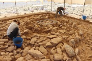
Research at Taş Tepeler, however, continues and continues to yield surprises. In fact, approximately two hundred kilometers east of Göbekli Tepe, the excavation of another Neolithic site , part of the same research project, is once again shaping our understanding of the process of sedentarization we mentioned earlier. At Mendik Tepe, near the village of Payamlı, an Anglo-Turkish excavation led by Professor Douglas Baird of the University of Liverpool is uncovering another Neolithic site, characterized by structures of varying sizes : small buildings likely used for storing or preparing food ; medium-sized structures—about five meters on a side —likely used for residential purposes; and—finally—large stone structures, which appear to have had some ritual and/or ceremonial significance.
In short, Mendik Tepe appears, for all intents and purposes, to be a real human settlement , equipped with all the structures necessary for the sustenance and “social needs” of a cohesive group of individuals. What could mark yet another reversal of perspective, however, is the dating of this site: according to Baird, in fact, the finds at Mendik Tepe appear to belong to the very early phases of the Aceramic Neolithic : the structures, although formally connected to those at Göbekli Tepe and the other large ceremonial site in the area, Karahan Tepe, display peculiar shapes and materials , with differences that could mark a more transitional and less defined phase in the construction processes and methods of the first sedentary humans. Furthermore, the structures and materials found show remarkable similarities with those of another of the Taş Tepeler sites, Çakmak Tepe, whose dating has already been established between 10,000 and 9600 BC.


